The Jesus Trail: A Fascinating Hike in Jesus’ Footsteps
The Jesus Trail is a 65 km (40 mi) hiking and pilgrimage route in the Galilee region of Israel. It connects many significant sites from Jesus’s life and ministry and was designed to offer travelers of diverse religious and ethnic backgrounds a deeper understanding of Jesus’s life.
By walking this trial people can witness first hand the land that shaped Jesus’ life. The trail encourages encounters with diverse groups of people and promotes the idea of simplicity and hospitality.
While it primarily targets Christians who seek a pilgrimage route in the Holy Land and sites from Jesus’s life, it also integrates historical sites from different eras, sites sacred to other religions, nature sites, and offers breathtaking panoramas for those seeking a physical challenge.

The Jesus Trail History and Significance
The Jesus Trail is based on a verse from the New Testament Gospel of Matthew, which describes Jesus moving from Nazareth to Capernaum. According to the Gospels, Capernaum became the home base for Jesus’ ministry.
It was founded in 2007 by Maoz Inon, a Jewish Israeli entrepreneur, and David Landis, a Christian American hiking specialist. Their idea was to create a trail in the tradition of pilgrimage trails around the world, such as the Camino de Santiago de Compostela in Spain and the Saint Paul Trail in Turkey.
The trail was marked a year after inception, in 2008, and is managed and promoted by volunteers as a non-profit project.


Jesus Trail sections: A detailed overview
The trail connects many sites from Jesus’s life and ministry, including: Nazareth, Sepphoris, Cana, Hattin, Arbel National Park, Sea of Galilee, Capernaum, Tabgha, Mount of Beatitudes. An alternate return route could include Tiberias, Jordan River, Mount Tabor, and Mount Precipice.
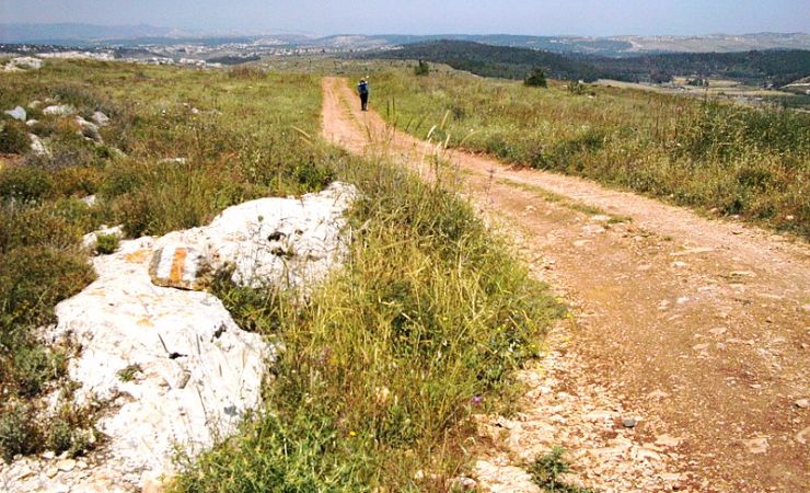
You should know the Jesus trail is well-marked and is mostly doable for people with a moderate level of fitness. However, it can be challenging in the heat so take care!
Below is one possibility for hiking the Jesus Trail. There are recommendations. Research the internet to find the right one for you.
Day 1: Nazareth to Cana via Sepphoris
- Distance: Approximately 15 km
- Difficulty: Moderate
- Route: The trail starts in the center of Nazareth at the Church of the Annunciation, goes through the Old City of Nazareth. Nazareth is mentioned no less than 17 times in the New Testament and is believed to be Jesus’ childhood home. Presently, Nazareth stands as Israel’s biggest Arab town, with a population of 80,000. The Jesus trail then ascends to the ridge overlooking the city. From there, it ventures into agricultural fields towards the ancient city of Tsippori (Sepphoris). The ruins of the old city of Sepphoris are part of the Tzippori National Park. The park is famous for its Byzantine floor mosaics including the Mona Lisa of the Galilee. The trail then heads east for about 6km to Kafr Kanna, where the day ends. Kfar Kana in where according to tradition, Jesus turned water into wine at a wedding. The Wedding Church commemorates this event.
Day 2: Cana to Kibbutz Lavi
- Distance: Approximately 17 km
- Difficulty: Moderate with some uphill sections
- Route: Leaving Cana, the trail goes heads about 8km through forests and cultivated fields of Tur’an, passing the Horns of Hattin, a significant historical site from the time of the Crusaders. The day concludes at the outskirts of Kibbutz Lavi that was established by British immigrants in 1949.
Day 3: Kibbutz Lavi to Moshav Arbel
- Distance: Approximately 15 km
- Difficulty: Moderate with some steep descents
- Route: This starts with a 5km walk to an view of the Druze shrine of Nabi Shu’ayb, the holiest site for the Druze. The Druze believe this is the burial site of Jethro, Moses’ father-in-law. Then there is a panoramic view of the Horns of Hattin where Saladin defeated the Crusaders in 1187. The trail then continues for almost 10km northeast, ending near Moshav Arbel which offers breathtaking views of the Sea of Galilee.
Day 4: Moshav Arbel to Capernaum via Mount of Beatitudes
- Distance: Approximately 18 km
- Difficulty: Moderate with some steep sections
- Route: After ascending from Moshav Arbel, there’s about a 5km descent to the ruins of the town of Magdala (Migdal), the hometown of Mary of Magdalene on the shores of the Sea of Galilee. At Magdala you can visit a synagogue from the time of Jesus and see the Magdala Stone. The trail then reaches the northern shore passing through Kibbutz Ginosar (where the Jesus Boat is located), Tabha (the Church of the Multiplication) the Mount of Beatitudes, and finally arriving at Capernaum.
Sources and Additional Reading
Jesus Trial Downloadable Map
Book: Hiking the Jesus Trail and Other Biblical Walks in the Galilee
The Jesus Trial Wikipedia


