Jerusalem Archeological Park: An Exciting Stroll Though Time
The Jerusalem Archeological Park, also known as the Davidson Center, offer visitors the opportunity to walk through the remains from the time of the Second Temple period.
Location
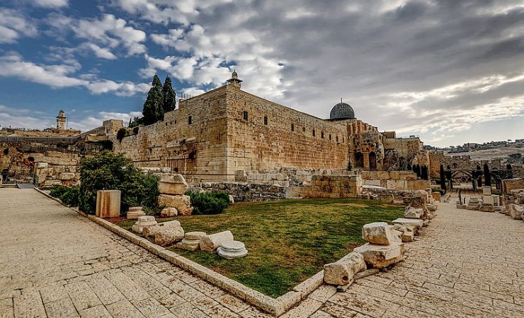
The Jerusalem Archeological Park, also known as the Davidson Center, is located in the Old City of Jerusalem. Specifically, it is situated to the south and southwest of the Temple Mount. It is minutes away from the Dung Gate.


Delving Deeper into the Jerusalem Archeological Park Findings
Some of the structures that can be seen at the Jerusalem Archeological Park include:
The Huldah Gates
The Huldah Gates, known in Hebrew as “Sha’arei Hulda,” were among the gates leading into the Jerusalem Temple. Remains of two gates from a later period can be seen: the Triple Gate and the Double Gate. Both these gates were constructed as part of the Herodian Temple Mount expansion and provided access to the Temple Mount via underground vaulted ramps. The source of the name “Huldah” has two potential origins: it means “mole” or “mouse” in Hebrew, possibly referring to the tunnel-like nature of the gates (ascending through the gates through tunnels and into sunlight when reaching the Temple Mount). Alternatively, it might be associated with the First Temple prophetess Huldah, who some believe had her tomb in this area.
The Herodian street and the huge stones that cover it
The Herodian street, discovered adjacent to the Western Wall, is believed to be the main thoroughfare of ancient Jerusalem. The street was uncovered for a total length of 70 meters and is about 10-12 meters wide, paved with large stones, carefully trimmed and joined together for comfortable walking. Three oil lamps of a type common in the first century CE and 17 coins struck by the Roman procurator of Judea, in the year 17/18 CE shows the street was completed many years after King Herod’s death in 4 BCE.
One of the most sad reminders of the Temple’s destruction in 70 AD by the Romans is the sight of massive stones that were hurled from the Temple Mount onto the street below. These stones, some weighing several tons, have lain there for nearly 2000 years. They are a testimony to the catastrophic events of that time.
The impressive staircase leading to the Temple
This grand staircase of steps leading to the Temple Mount is unique because of its steps of varying sizes. It is believed that this design was intentional, ensuring that the pilgrims would approach the Temple in a slow and respectful manner, without rushing. For people ascending the steps, it would be the perfect time to think and reflect.
The Corner of the Temple with the Remaining Inscription
During the 1970s, a large corner stone with a typical Herodian profile had been found lying in the street below the southwestern corner of the Temple Mount. On this stone, a Hebrew inscription, partially preserved, is carved: “To the trumpeting place to…”. The stone had stood at the top of the southwestern corner of the Temple Mount, from where the Temple priests announced the onset of the Sabbat and other Jewish festivals. Read more details below.
Abundant Mikves
The Davidson Center area is home to several ritual immersion baths or Mikves. These Mikves are a testament to the religious practices and the importance of ritual purity during the Second Temple period. It was mandatory to bathe in the Mikve before entering the Temple Mount.
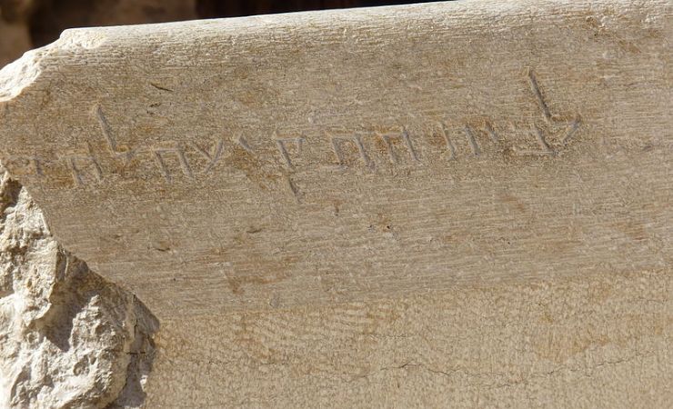
A Focus on the Corner of the Temple Inscription
During the 1970s, in the excavations along the southwestern corner of the Temple Mount, a large corner stone with a typical Herodian profile was discovered.
This stone bore a partially preserved Hebrew inscription that read: “To the trumpeting place to…” (לבית התקיעה לה…. The most plausible reconstruction of the missing end of this inscription is either “proclaim” or “separate.” (להכריז או להבדיל in Hebrew).
This inscription provides valuable insights into the rituals of the Second Temple period. It is believed that the stone marked the spot where a priest would blow a trumpet to signal the beginning and end of the Sabbath. Before Shabbath, he would blow a six times at set intervals offering all Jews in the surrounding a countdown until Sabbath. This ritual was crucial, as it helped synchronize the observance of the Sabbath across the city, ensuring that all activities ceased, and the day of rest was observed by all.
Significance and Interpretation
The discovery of the Corner of the Temple Inscription at the Jerusalem Archeological Park reinforces the historical accounts and rabbinical sources that describe the custom of trumpeting from the Temple Mount. This practice is mentioned in various Jewish texts, including the Babylonian Talmud and the writings of the 1st-century historian Josephus Flavius.
“And on Shabbat eve they would add six blasts sounded adjacent to the onset of Shabbat: Three to stop the people from their labor, as the blasts inform the people that Shabbat is approaching and they stop working, and three at the onset of Shabbat to demarcate between sacred and profane…” (Sukkah 5:5).
“And having the advantage of situation, they further erected four very large towers… where one of the priests usually stood and gave a signal beforehand in the evening with a trumpet at the beginning of every seventh day, as also in the evening when the sabbath day was finished, giving notice to the people when they were to leave off work, and when they were to go to work again…” (Wars of the Jews, 4.9.12).
The location of this stone and its inscription also underscores the meticulous organization and the importance of rituals during the Second Temple period. The act of trumpeting from such a prominent location ensured that the sound carried far and wide, reaching the residents of Jerusalem and the many pilgrims in the city.
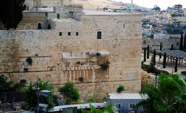
A Focus on the Robinson Arch
Robinson’s Arch is a monumental staircase, supported by an unusually wide stone arch. It is named after the Biblical scholar Edward Robinson who identified its remnants in 1838. The arch once served as a primary entrance to the Temple Mount during the time of Herod the Great. The Robinson’s Arch is located at the southwestern corner of the Temple Mount.
Historical Background
Robinson’s Arch was constructed as part of King Herod’s renovation and expansion of the Second Temple, which began around 20–19 BCE. It was designed to link the Tyropoeon Valley street, a major traffic artery during the Second Temple Period, with the Royal Stoa at the southern end of the Temple Mount platform. This connection was vital, as the Tyropoeon Valley street was lined with shops and formed part of the city’s Lower Market. The Royal Stoa, a grand basilica complex, overlooked this intersection from atop the Temple platform and was a center of both commercial and legal activities.
Architectural Significance
The arch, was initially believed to be part of a series of bridges leading from the Upper City to the Temple Mount. However, later excavations revealed that the arch, along with a row of small vaults, supported a flight of steps leading from the street to the Temple Mount. This discovery debunked the earlier theory that the arch was part of a bridge system.
The arch’s design was monumental, with the staircase carried by the wide stone arch spanning over the streets below. The stones used in its construction were of local limestone, it was about 15.2 meters wide and weighed about 1,600 tons. and the arch stood at a height of about 17 meters above the street level.
Destruction and Rediscovery
Robinson’s Arch was destroyed at 70AD, during the First Jewish–Roman War, only a few decades after its completion. Edward Robinson’s discovery offered a significant contribution to the field of Biblical archeology, as it provided real evidence of the architectural wonders described in ancient texts. The remains of this magnificent arch can be seen today at the Jerusalem Archeological Park, Davidson Center.
Nearby Sites
-
Dung Gate: One of the Old City’s gates. Provides access to the Western Wall and important sites of the Jewish Quarter such as the Broad Wall, The Western Wall Tunnels, the Roman Cardo, and the Hurva Synagogue.
-
Kidron Valley: The Kidron Valley runs between the Temple Mount and the Mount of Olives. Within the valley, you’ll find several ancient tombs, including the Tomb of Absalom, the Tomb of Zechariah, and the Tomb of Benei Hezir.
-
Pool of Siloam: An ancient freshwater reservoir. It is mentioned in both the Old and New Testaments.
-
Hezekiah’s Tunnel: An underground water channel that was carved beneath the City of David. Constructed to secure water for Jerusalem during the Assyrian siege.

